
In 1872, SU Roberts, the Galway County Surveyor, wrote: “The lower lake empties its waters through a delta by three visible outlets: the natural and original shallow, tortuous and rocky Corrib River, navigable for only very small craft and row-boats on the west; the Mionloch Creek, a small stream, on the east and now nearly filled up; and through the boggy island covered with sedge between these two, by means of the “Friar’s Cut”, a canal of about three-quarters of a mile in length, fifty feet wide and twelve deep through the main stream passes. Besides these three streamways, there is a subterranean communication through the cavernous limestone, by means of ‘swallow holes’ near Tír Oileáin on the eastern shore which formerly carried off a large portion of the surplus waters of the lake, and discharged them into the sea near Oranmore”.
The works on the improvement of the drainage, navigation and water power in connection with Lough Corrib went on from 1848 to 1857, and followed the work on the development of the new dock which had started in 1845.
“The Eglinton Canal at Galway is a work of great utility, both in draining and regulating the surplus waters of the lake, and permitting ingress from the sea. The result obtained by these works has been, first, to relieve the 13,685 statute acres of the low lands on the margins of Loch Corrib and the various tributaries that flow into it, from flooding; secondly, the connexion of the Bay of Galway with Loch Corrib by a navigable canal and the opening up of the navigation of the lake; and thirdly, the improvement of the water power and mill-power of the river." The water-power was increased to the extent of about 1200 horsepower; it formerly did not exceed 400. The canal was a feeder channel to the Gaol River and the Western River and the various mills they powered. Some of those were the Galway Jute and Bag Factory, the Galway Granite and Marble Factory, Persse’s Distillery, The Clog Sole and Bobbin Factory, the Ammunition Factory, various woollen mills and flour mills and a number of smaller businesses.
There were also a number of rowing clubs along the canal - The Royal Galway Yacht Club, University College Boat Club and St Patrick’s Temperance Club among them.
The level of the lake was lowered by three feet. The summer level of the lake was now 14 feet above that of the high water of ordinary tides in Galway Bay. The ascent from the Claddagh Basin to the level of the lake was accomplished by one lock, 130 feet long, and twenty-one wide with a lift of fourteen feet. There was another lock at the entrance to the Claddagh Basin and there were also swivel bridges constructed from a wrought iron frame with timber decking at five road crossings. The Claddagh Basin was constructed to cater for the 300 boats that were operating from the Claddagh at the time. The entire project provided much needed employment during and immediately after the Famine.
Water was let into the canal for the first time on September 15, 1851. The formal opening took place on August 28, 1852. It was performed by the Lord Lieutenant, Lord Eglinton. He and his wife were on the steamboat O’Connell when it was raised up at the Parkaveara Lock from where they proceeded up to Menlo Castle where a royal salute was fired and then their Excellencies steamed back to Galway.
The canal could accommodate vessels up to 125 feet and of a 20 foot beam. Initially, it was a big success with a lot of commercial traffic plying between the lake and the sea. In 1880, £370 was collected in tolls. In 1904, 3,194 tons was carried through and the revenue £992, but by 1915, there was almost no commercial traffic. Motor traffic was getting heavier and heavier on the roads and this was putting increasing pressure on the swivel bridges. In 1954, they were found to be in an unsafe condition and were replaced by fixed bridges. This effectively finished the canal as a navigation channel.
It is still an important part of the fabric of the city, an open space, a beautiful calming walkway though an increasingly busy system of traffic-filled streets.
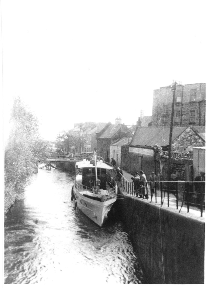
Our first photograph is courtesy of the National Library, dates from c1890 and shows the upper part of the canal before houses were built along there. Our second image was taken in 1954 near Pump Lane. It shows the swivel bridge at Balls Bridge being dismantled. The boat we see was the Amo II, the last such vessel to head out to sea via the canal.
