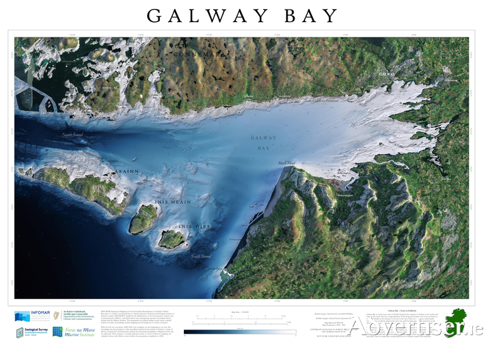
Ireland's seabed mapping programme, INFOMAR, has launched a new series of blue scale maps, featuring 18 high-resolution bathymetric maps of Ireland’s coastal waters, beginning with a high resolution map of Galway Bay.
Developed by a dedicated team of hydrographers, data processors and cartographers, the maps highlight the topography of the coast in unprecedented detail. The programme will publish maps on a weekly basis over the coming months, finishing with a high res map of the Aran Islands on December 15.
INFOMAR - Integrated Mapping for the Sustainable Development of Ireland’s Marine Resource - was established in 2006 and is currently one of the world’s leading seabed mapping programmes.
The programme, funded by the Department of the Environment, Climate and Communications, is a joint venture by the Marine Institute and Geological Survey Ireland and aims to map Ireland’s seabed and deliver a comprehensive baseline bathymetry dataset to underpin the future management of Ireland’s marine resources.
Ireland’s coastline is 3,171km in length and boasts some of the most unique and dynamic environments in Europe. This new blue scale map series is the culmination of over a decade of work and highlights the intricate landscapes that lie beneath the waves. Each map is carefully drawn to include the latest high resolution INFOMAR bathymetry (water depth ) data.
As with all INFOMAR data, the new high-resolution maps are available for all to download for free. The Galway Bay map is available at www.infomar.ie/galleries/node/565
People can follow the journey each week as a new map is released on the INFOMAR website, and join the conversation on Twitter, Instagram and Facebook.
