Search Results for 'www.galwaycivictrust.ie'
5 results found.
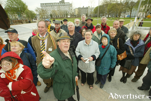
Galway gathers to honour Peadar O’Dowd
Galway’s historic Druid Lane will come alive with voices, music, and stories on Saturday, August 23 as the city gathers to honour the life and legacy of Peadar O’Dowd, the beloved historian, author, and champion of Galway’s heritage.
A life steeped in story: Remembering Peadar O’Dowd, Galway’s beloved chronicler
Galway has always been a city of stories—tales whispered through stone walls, sung across the bay, and told beside fire and pub counter. But few told them as lovingly and thoroughly as Peadar O’Dowd. Historian, teacher, author, environmentalist, tour guide, columnist, and tireless ambassador for Galway’s past, Peadar passed away on January 4, 2024, leaving behind a city immeasurably richer for his life’s work and immeasurably poorer in his absence.
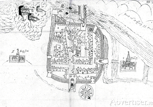
Medieval Galway

This very stylised plan of Galway was made in 1583 by Barnaby Googe and is the earliest surviving map of the city. It shows the walled town as it stood at the end of the medieval period. Galway was packed with houses: the D-shaped circuit of walls with mural towers and gates was complete; there was only one bridge over the fast flowing river, which was also an important salmon fishery, and it possessed a wharf or landing place for ships. The parish church of St Nicholas and the central market place with its market cross were prominent in the townscape, which was structured around the northeast/southwest axis of Shop Street branching into Main Guard Street and High Street/Quay Street.
Medieval Galway
This very stylised plan of Galway was made in 1583 by Barnaby Googe and is the earliest surviving map of the city. It shows the walled town as it stood at the end of the medieval period. Galway was packed with houses: the D-shaped circuit of walls with mural towers and gates was complete; there was only one bridge over the fast flowing river, which was also an important salmon fishery, and it possessed a wharf or landing place for ships. The parish church of St Nicholas and the central market place with its market cross were prominent in the townscape, which was structured around the northeast/southwest axis of Shop Street branching into Main Guard Street and High Street/Quay Street.
Heritage events continue
Heritage week continues in Galway with a programme of events organised by the Galway Civic Trust.

