Search Results for 'National Library'
38 results found.
The Regional Hospital under construction
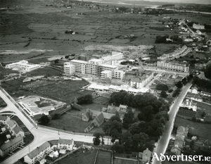
The National Library gave us this aerial photograph of the ‘Regional’ under construction in 1953. The foundation stone for the hospital was laid in 1949 by Dr Noel Browne, the Minister for Health. Just in front of it you can see the old Central Hospital. The building of the new involved the demolition of the rear wing of the old Central. Long-term patients in the Central were accommodated in temporary huts located in front of the building, an arrangement that allowed the Central to function more or less normally during construction.
The canal
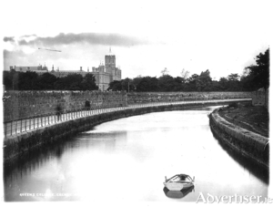
In 1872, SU Roberts, the Galway County Surveyor, wrote: “The lower lake empties its waters through a delta by three visible outlets: the natural and original shallow, tortuous and rocky Corrib River, navigable for only very small craft and row-boats on the west; the Mionloch Creek, a small stream, on the east and now nearly filled up; and through the boggy island covered with sedge between these two, by means of the “Friar’s Cut”, a canal of about three-quarters of a mile in length, fifty feet wide and twelve deep through the main stream passes. Besides these three streamways, there is a subterranean communication through the cavernous limestone, by means of ‘swallow holes’ near Tír Oileáin on the eastern shore which formerly carried off a large portion of the surplus waters of the lake, and discharged them into the sea near Oranmore”.
One hundred years of golf at Blackrock/Pollnarooma
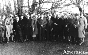
In December 1923, the committee of Galway Golf club, then based at Barna, decided to explore the idea of acquiring the late Col O’Hara’s estate at Blackrock and on April 24, 1924, they bought the West Lodge and the land at Pollnarooma for £4,750 plus £237 auctioneer’s fees. Messrs Tighe, Kennedy, Lenihan and Quinlan were appointed to oversee the laying out of the new course and the renovation of West Lodge which had been Col O’Hara’s house.
The Galway Electric Light Company
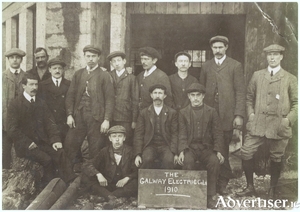
The Galway Electric Light Company was set up by James Perry, an engineer and County Surveyor of the Western District of Galway, and his brother, Professor John Perry, to generate electricity. On November 1, 1888, they applied for permission from the Galway Town Commissioners to ‘erect poles in some parts of the town as an experiment for the electric lighting of the town’. The company had established a generating station at Newtownsmith in an old flour mill which had existed since the 1600s and straddled the Friar’s River. They installed a hydroelectric turbine in the watercourse which was linked to a generator producing alternating current.
The Franciscans in Galway
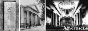
In the graveyard at the back of the Abbey Church in Francis Street stands an interesting memorial carrying the De Burgo coat of arms and a long broadsword. The inscription tells us that it was erected in memory of William De Burgo who founded the Franciscan friary on St Stephen’s Island in 1296. The site was roughly where the Courthouse is today and the island was formed by the Galway River on one side and a branch of that river which ran through what today would be Woodquay and Mary Street and re-joined the main river. A second and smaller island lay between St Stephen’s and the town wall, so that in order to maintain communications with the town, two bridges were necessary, one at the junction of Mary Street and Abbeygate Street and the other at the Little Gate. The Abbey buildings lay immediately north of the present graveyard and between them and the river was ‘Sruthán na mBráthair’, a small stream that enabled the friars to bring boats in from the main river. The monastery was known as the Abbey of St Francis.
Fairs and markets in the Square
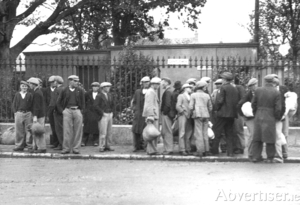
In 1902, the number of fairs listed for Eyre Square was: January 1st; March 20th & 21st; April 14th & 15th; May 30th & 31st; June 20th; July 13th & 14th; August 6th; September 3rd & 4th, 20th & 21st; October 21st; November 2nd (pigs only); and December 8th & 9th. This list gives one an idea of how important and busy the Square was for commerce at the time. These were occasions when the country came to town, when rural people brought in their produce and hoped to convert it into cash.
The age of sail
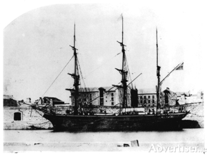
“A river mouth opening upon one of the finest natural harbours would seem to offer an ideal situation for a town or trading station.” These were the first words written in Professor Mary Donovan O’Sullivan’s very important history Old Galway, which would indicate her surprise that such a fine location would not have attracted a Norse settlement. Water, in the form of the sea, the river and the many streams, was a major factor in the development of the town of Galway from when the Anglo Norman invaders settled and built their castle and town.
A medieval castle in Quay Street
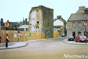
Blake’s Castle is a medieval urban fortified town house at the bottom of Quay Street which was built c1470 with single bay ground and first floors and a two-bay second floor. It has a flat roof with a crenelated parapet with a projecting machicolation on supporting corbels on the top floor above the entrance. This was an opening at the parapet through which defenders could drop material such as boiling water or hot pitch down on would-be attackers. It was built with coursed roughly dressed limestone rubble walls with square headed window openings to the upper floors.
Bianconi in Galway
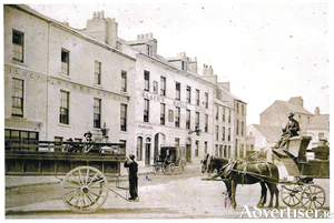
Charles Bianconi is generally regarded as the man who put Ireland on wheels. He developed a network of horse-drawn carriages that became Ireland’s first integrated transport system, building on the existing mail roads and coach roads that were already there. There was a general tax on coaches at the time, which precluded the middle classes from using theirs, and a relatively peaceful period after the Battle of Waterloo meant that a great many horses, bred for the army, became cheap on the market. His system offered connections with various termini, his prices were cheap and so he was well patronised, in spite of the discomfort felt by passengers. Often, when going up a hill, some passengers would alight to make the carriage lighter for the horses.
The changing face of Kingshill
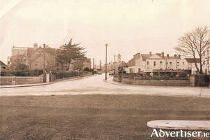
Our first photograph today (courtesy of the National Library) is a bird’s eye view that was taken in 1953 and shows the Warwick Hotel at the top of the picture. Next to it on the right was the entrance to Lenaboy Park, and beyond that you can see part of Queeney’s shop. Next door was Doorley’s private house and then Mrs Turke’s B&B called Osterley Lodge. Opposite, on the far side of the road was Billy Binn’s house and on the corner, as you can see, was a field with a lot of trees, much used as a playground by local children. This whole area was very prone to flooding and was occasionally rendered impassable, as was the case with Hurricane Debbie.

