Search Results for 'Thomas Phillips'
4 results found.
Our fortified city
The town of Galway was virtually an independent city state, self-contained politically and ecclesiastically, relying on its own resources as it was cut off from the central English authority until the 16th century. Then, the Tudors began to extend their influence westwards so that the city gradually came totally under their dominion. The real symbol of that growing influence was the fortifications, four in number, raised to defend this all-important location against all enemies, notably France and Spain.
The West Bridge, a brief history of the early years
The city of Galway was known in ancient times as ‘Streamstown’ because the Galway River divided into several small waterways in addition to the main river. The river was much more spread out then and was fordable in some places. The city was placed on the east side of the river, which acted as protection against the Irish families displaced by the Norman settlers who took over the area in the early 13th century. The walls of the city provided protection on the east and north side of the city and the various gates allowed access. The river was a barrier to trade with Iar-Chonnacht and so the merchant families began to feel the need to build a bridge to help expand trade, it would provide access to customers from the west, and also allow them to bring in their produce, fruit, vegetables, meat, hay, etc, to the various markets in town.
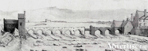
Balls Bridge, 1685
This drawing is of a detail from “A Prospect of Galway” drawn by Thomas Phillips in 1685. It shows the southern end of the middle suburb with Balls Bridge on the left, and the bit of an arch you can see on the far right was part of the West Bridge. Balls Bridge is the bridge over what is now the canal between Upper and Lower Dominick Street, and the buildings we are looking at would be the backs of Lower Dominick Street as seen roughly from across the road from where the Fisheries Tower is today. The West Bridge is where O’Brien’s Bridge is today.
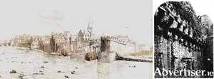
A prospect of Galway, 1685
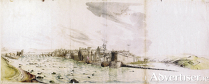
This hand coloured prospect of Galway, looking northeast, was drawn in 1685 by Captain Thomas Phillips, surveyor-general of the fortifications in Ireland. It is especially important as it is the only quasi-objective pictorial record of Galway to survive from this period.

