Search Results for 'Paul Walsh'
42 results found.
Galway, historic towns atlas
On Monday next, November 1st, President Michael D. Higgins will launch the latest title in a series of Historic Towns Atlases of Ireland. This one is on Galway and is compiled by Jacinta Prunty and Paul Walsh. It is essentially an illustrated history of the development of the built up area of the city as seen through 57 illustrations starting with the earliest printed maps of Galway, antiquarian prints, 19th century paintings and photographs. Many of these are in colour, and many are A3 in size.
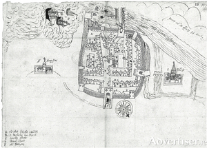
GALWAY c1200 to c1900
The above is the title of a newly published folding map by the Royal Irish Academy. It has been compiled by Jacinta Prunty and Paul Walsh using the extensive topographical information which they collected while working on a forthcoming book entitled Galway in the Historic Towns Atlas series. They also studied old maps of the city. This map extends from Newcastle Road to College Road and from Terryland to Nimmo’s Pier. The map and its extensive indices are unrivalled in their detail and afford a unique window into the earlier medieval topography and way of life in the city.

