Search Results for 'Margaret Laffey'
1 results found.
Steamer’s Quay
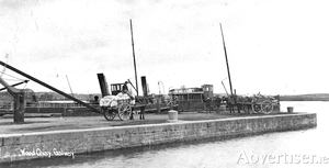
Alexander Nimmo made a survey of Lough Corrib almost 200 years ago in which he wrote the following: “The lake has 50 miles of shore, occupies 30,000 Irish acres and contains 1,000 acres of arable land in its isles, and contracts into a very spacious river about two and a half miles above Galway, which, flowing by the town, communicates with the Atlantic. The fall from the summit of the lake to the sea is considerable, but to the Wood Quay, above the town, it is trifling, and the river is in parts very shallow, running over a bed of rocks and hard gravel. It is not navigable from the sea to the Wood Quay owing to its shallowness and the rapidity of the water, and none but small boats can come down; but unless in very dry seasons, it is thence navigable by boats drawing four feet of water and carrying from ten to twenty tons, with one square sail and four men, to Cong. They seldom sail, unless before the wind, and though the lake has many islets and sunken rocks, the only serious difficulty in navigation is at Buachally Shoal about four miles up the lake, and at Newcastle. These shoals could be deepened for a small sum and the whole made to admit vessels of much greater magnitude. The fine navigation which extends about 30 miles, and into a seaport town, seems to deserve more attention than it has yet received. A good chart with soundings and sailing instructions should be published, the shoals or rocks cleared or beaconed, and a communication opened with the sea.”

