Search Results for 'Jacinta Prunty'
5 results found.
Our fortified city
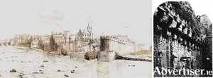
The town of Galway was virtually an independent city state, self-contained politically and ecclesiastically, relying on its own resources as it was cut off from the central English authority until the 16th century. Then, the Tudors began to extend their influence westwards so that the city gradually came totally under their dominion. The real symbol of that growing influence was the fortifications, four in number, raised to defend this all-important location against all enemies, notably France and Spain.
Medieval Galway

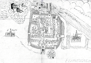
This very stylised plan of Galway was made in 1583 by Barnaby Googe and is the earliest surviving map of the city. It shows the walled town as it stood at the end of the medieval period. Galway was packed with houses: the D-shaped circuit of walls with mural towers and gates was complete; there was only one bridge over the fast flowing river, which was also an important salmon fishery, and it possessed a wharf or landing place for ships. The parish church of St Nicholas and the central market place with its market cross were prominent in the townscape, which was structured around the northeast/southwest axis of Shop Street branching into Main Guard Street and High Street/Quay Street.
Medieval Galway
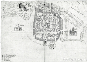
This very stylised plan of Galway was made in 1583 by Barnaby Googe and is the earliest surviving map of the city. It shows the walled town as it stood at the end of the medieval period. Galway was packed with houses: the D-shaped circuit of walls with mural towers and gates was complete; there was only one bridge over the fast flowing river, which was also an important salmon fishery, and it possessed a wharf or landing place for ships. The parish church of St Nicholas and the central market place with its market cross were prominent in the townscape, which was structured around the northeast/southwest axis of Shop Street branching into Main Guard Street and High Street/Quay Street.
Galway, historic towns atlas
On Monday next, November 1st, President Michael D. Higgins will launch the latest title in a series of Historic Towns Atlases of Ireland. This one is on Galway and is compiled by Jacinta Prunty and Paul Walsh. It is essentially an illustrated history of the development of the built up area of the city as seen through 57 illustrations starting with the earliest printed maps of Galway, antiquarian prints, 19th century paintings and photographs. Many of these are in colour, and many are A3 in size.
GALWAY c1200 to c1900
The above is the title of a newly published folding map by the Royal Irish Academy. It has been compiled by Jacinta Prunty and Paul Walsh using the extensive topographical information which they collected while working on a forthcoming book entitled Galway in the Historic Towns Atlas series. They also studied old maps of the city. This map extends from Newcastle Road to College Road and from Terryland to Nimmo’s Pier. The map and its extensive indices are unrivalled in their detail and afford a unique window into the earlier medieval topography and way of life in the city.

