Search Results for 'Griffith'
3 results found.
Kirwan’s Lane, a bird’s eye view
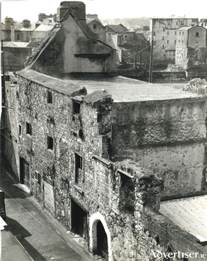
This lane is one of the most attractive in Galway and one of the most historic. There were originally 14 lanes in medieval Galway and this is one of the few that still exist. It dates back to the 16th century. As our photograph shows, it must have been very impressive back then.
Bowling Green
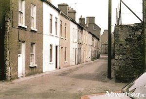
Bowling Green first appears without a name on a map in 1608. It features a little later as Bóthar Alasandair or Alexander’s Lane (eventually shortened to Sander’s Lane) which in turn was named after Alexander’s Tower, a medieval tower nearby. It is difficult to know exactly when the name Bowling Green originated, but we must presume there was a bowling green in the area at some point. On an Ordnance Survey map of 1839, the part of Bowling Green we see in our photograph was known as ‘Bowling Green Lane’ while the section connecting with Lombard Street was known as ‘The Bow’. Both sections are collectively known as Bowling Green today.
A view from the rear of the Spanish Arch
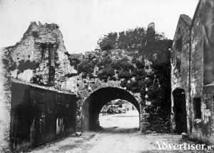
The Spanish Arch was not part of the original city walls but was built in 1584 as a measure to protect the city’s quays. It was originally known as Ceann an Bhalla or The Head of the Wall, a fortification that extended from Martin’s Tower to the river. Then in the 18th century, the Eyre family built Long Walk as an extension of the quays and a breakwater to construct a mud berth. A number of arches were constructed to allow access from the town to the new quay but unfortunately, an earthquake that occurred in Lisbon in 1755 resulted in a tsunami that destroyed some of these arches. In olden times, ships would have moored here unloading their cargo of Spanish wines and foodstuffs such as olive oil, spices, tea, coffee, and cocoa. Later, these ships would have been replaced by Aran fishing boats unloading and selling their wares.

