Search Results for 'Galway River'
15 results found.
Drowned princess smothered in red tape
A seven foot, bronze statue celebrating the mythical princess who drowned in the Corrib and gave her name to Galway, is languishing in a plywood crate, in a back yard, in Wicklow.
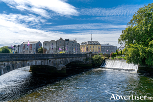
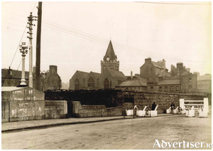
The Galway River, 1952
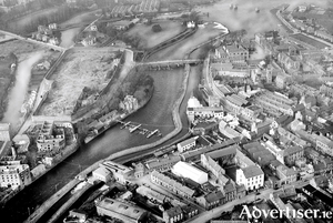
If you are in an aeroplane flying over a village or town, you get a fleeting impression of what that village looks like, but if one knows how to operate a very good camera while flying the aircraft, you might get a pin-sharp illustration of what that village looks like and how it is laid out. That is exactly what our pilot/photographer did in 1952 when he/she took this shot of the river from the Salmon Weir down to the Hygeia building.
New Tiny Treasure Hunt at Galway City Museum
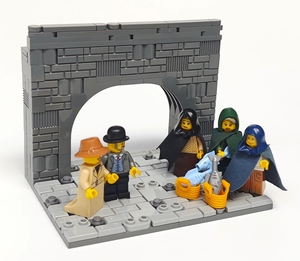
Galway City Museum commissioned LEGO® brick artist, Jessica Farrell, to create twelve tiny models, using LEGO® bricks and minifigures, to depict scenes from Galway’s past and present. The mini models featuring Pádraic Ó Conaire, Grace O’Malley, Turlough O’Connor and St MacDara, to name a few, have been strategically placed at different locations throughout the museum. The aim of the new Tiny Treasure Hunt is to find all characters and tick them off as you navigate through the galleries.
The lock keeper’s house
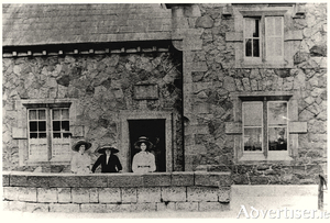
The Eglinton Canal was a work of great utility both in terms of draining and regulating the surplus waters of the lake and permitting ingress from the sea. The lower lake used to empty its waters through a delta by three visible outlets into the sea; The natural and original shallow tortuous and rocky Galway River, navigable only for very small craft and row-boats; The Mionlach creek, a small stream nearly filled up; “The Friar’s Cut”, about three quarters of a mile in length, fifty feet wide and twelve feet deep.
The Franciscans in Galway
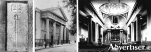
In the graveyard at the back of the Abbey Church in Francis Street stands an interesting memorial carrying the De Burgo coat of arms and a long broadsword. The inscription tells us that it was erected in memory of William De Burgo who founded the Franciscan friary on St Stephen’s Island in 1296. The site was roughly where the Courthouse is today and the island was formed by the Galway River on one side and a branch of that river which ran through what today would be Woodquay and Mary Street and re-joined the main river. A second and smaller island lay between St Stephen’s and the town wall, so that in order to maintain communications with the town, two bridges were necessary, one at the junction of Mary Street and Abbeygate Street and the other at the Little Gate. The Abbey buildings lay immediately north of the present graveyard and between them and the river was ‘Sruthán na mBráthair’, a small stream that enabled the friars to bring boats in from the main river. The monastery was known as the Abbey of St Francis.
Weekend of riverside drama in city centre
Emergency services responded to four separate riverside incidents in Galway’s busy city centre last weekend.
Remembering Maurice Semple
Maurice Semple was born in 1917, a member of a family that had continuous connection with the ‘Citie of the Tribes’ for over 400 years, one of three children of Frank Semple and Elizabeth ffrench. His father worked in a clerical capacity in the courthouse, his mother was one of the ffrenchs from Claregalway. Both his brother ffrench Semple and his sister Mary predeceased him.
Inis Caorach, Mutton Island
In the year 1124, the town was put in a state of security and a strong castle was built at Dún Bun na Gaillimhe (the fortification at the mouth of the Galway River). Several times in the next century, the kings of Munster invaded Connacht bringing death and destruction and usually destroying the town and the buildings on the island. In 1190, there is a reference to Lismacuan, ‘The fort on the Mouth of the Harbour’
O’Brien’s Bridge
The Parliamentary Gazetteer of Ireland was published in 1845 and stated that, “The old, or west bridge, over the main current of the Galway River, was built in 1342; and till the erection of the new bridge [the Salmon Weir Bridge, built 1819] was the only passage from the eastern districts of the county to the great peninsulated district of Iar-Connaught. In 1558, a gate and tower were erected at its west end; and afterwards, another gate and tower were erected in its centre; but these were long ago entirely demolished. About 42 years ago, the bridge was thoroughly repaired on its north side, and was pronounced by architects to be strong; but it soon experienced the effects of the neglect which are so generally apparent in the town; and in consequence of dilapidated parapets, narrow carriage-way and the utter want of side-pavements and of lights, it was, a few years ago, a rather hazardous means of crossing a deep and impetuous river on a dark night.”
The West Bridge, a brief history of the early years
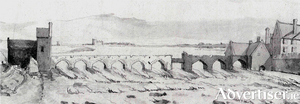
The city of Galway was known in ancient times as ‘Streamstown’ because the Galway River divided into several small waterways in addition to the main river. The river was much more spread out then and was fordable in some places. The city was placed on the east side of the river, which acted as protection against the Irish families displaced by the Norman settlers who took over the area in the early 13th century. The walls of the city provided protection on the east and north side of the city and the various gates allowed access. The river was a barrier to trade with Iar-Chonnacht and so the merchant families began to feel the need to build a bridge to help expand trade, it would provide access to customers from the west, and also allow them to bring in their produce, fruit, vegetables, meat, hay, etc, to the various markets in town.

