Search Results for 'Upper Citadel'
2 results found.
A Galway tradition
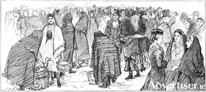
The origins of the centuries-old Saturday market are lost in the mists of time. It was always held in front of St Nicholas’ Collegiate Church, which was the only open space in the old walled town. Two hundred years ago, James Hardiman, in his history, was writing that, “The town is well supplied with vegetables … the green gardeners cultivate a considerable quantity of ground and keep a considerable supply of remarkable fine-flavoured fruit and vegetables.” At the same time, Hely Dutton, in his survey, was writing, “The vegetable market kept near the Main Guard is generally well supplied, and at reasonable rates; all kinds come to the market washed, by which any imperfection is easily detected. The cabbage raised near the sea side on seaweed is particularly delicious; those who have been used to those cultivated on ground highly manured, cannot form any idea of the difference. There are also, in season, peaches, strawberries, gooseberries, apples, pears etc.”
GALWAY c1200 to c1900
The above is the title of a newly published folding map by the Royal Irish Academy. It has been compiled by Jacinta Prunty and Paul Walsh using the extensive topographical information which they collected while working on a forthcoming book entitled Galway in the Historic Towns Atlas series. They also studied old maps of the city. This map extends from Newcastle Road to College Road and from Terryland to Nimmo’s Pier. The map and its extensive indices are unrivalled in their detail and afford a unique window into the earlier medieval topography and way of life in the city.

