Search Results for 'Alexander Nimmo'
9 results found.
The view from the distillery, c1885
Towards the end of last year, we featured a series of articles on the building that is now occupied by the students’ bar in NUIG. The building started as a jute bag factory, then was converted to a bonded warehouse for Persse’s Distillery, later became the National Shell factory during World War I, was occupied by the 17th Lancers and the 6th Dragoon Guards, before being converted into the ammunitions factory known as IMI.
Clifden’s Parisian boulevards
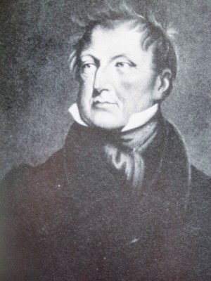
The man who opened Connemara to the traveller, and built an infrastructure to encourage trade and commerce in what was a wilderness of bog, mountain, and a rocky sea coast, was the Scottish engineer Alexander Nimmo. He was originally commissioned to investigate the possibility of draining the bogs, and replace them with a landscape of arable land suitable for farming. But Nimmo was the original man who thought outside the box. In his report of 1812 he outlined the total neglect of the region which had about 30,000 inhabitants, mostly living along her coast, eking out a bare subsistence livelihood. But he saw huge potential in the natural wealth of Connemara for tourism, and limited industry. He reported that there were large quantities of fish in its lakes and sea, and abundant seaweed for manure and for the manufacture of kelp. Its agriculture was undeveloped, its bogs badly harvested. All this neglect could be remedied
Nimmo’s, anecdotes, and recipes with Harriet Leander
ONE OF the best-loved Galway restaurants of recent years has been Nimmo’s on the Spanish Arch and the eateries’ many devotees will be delighted to learn that Harriet Leander, the genial Finnish chef who did so much to establish its reputation, has just published a wonderful book, entitled Nimmo’s; Anecdotes and Recipes, combining recipes of favourite Nimmo’s dishes with a wealth of great stories and illustrations.
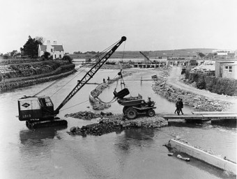
Dredging the river
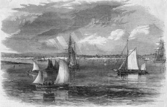
Alexander Nimmo made a survey of Lough Corrib almost 200 years ago in which he wrote the following: “The lake has 50 miles of shore, occupies 30,000 Irish acres and contains 1,000 acres of arable land in its isles, and contracts into a very spacious river about two and a half miles above Galway, which, flowing by the town, communicated with the Atlantic. The fall from the summit lake to the sea is considerable, but to the Wood Quay, above the town, it is trifling, and the river is in parts very shallow, running over a bed of rocks and hard gravel. It is not navigable from the sea to the Wood Quay, owing to the shallowness and rapidity of the water, and none but small boats can come down; but, unless in very dry seasons, it is thence navigable by boats drawing four feet of water and carrying from ten to twenty tons, with one square sail and four men, to Cong. They seldom sail unless before the wind, and though the lake has many islets and sunken rocks, the only serious difficulty in navigation is at Buachally Shoal about four miles up the lake, and at Newcastle. These shoals could be deepened for a small sum and the whole made to admit vessels of much greater magnitude. This fine navigation which extends about 30 miles, and into a seaport town, seems to deserve more attention than it has yet received. A good chart with soundings and sailing directions, should be published, the shoals or rocks cleared or beaconed, and a communication opened with the sea.”
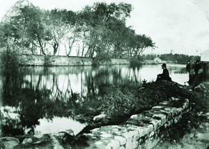
The Eglinton Canal
In 1498, during the mayoralty of Andrew Lynch, an attempt was made to open a passage from the River Corrib along the Sandy River and through land to Lough Atalia, thus connecting the river to the sea.
Learn about Alexander Nimmo at city lecture
“Bridges of Nimmo” is the title of a lecture to be given by Noel Wilkins, an emeritus professor of NUI Galway, at the Harbour Hotel, Dock Road on Monday at 8pm.
Sean Broderick and the Black and Tans
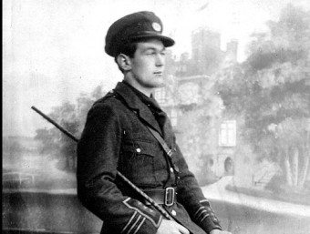
During the Black and Tan era, it was difficult for the IRA to be overtly active in Galway City because it was so heavily garrisoned. Renmore Barracks which was the headquarters of the Connaught Rangers, was occupied by the Sherwood Foresters, more of whom were based in Oranmore: There was a large detachment of the 17th lancers at Earl’s Island: The Auxiliaries had a Company in Lenaboy Castle: And, between the barracks in Eglinton St., two more barracks in Dominick St and many private houses which had been commandeered, there were some 500 men. In addition there were, at varying times, a number of troops camped near Galway.
A Galway Christmas book hamper
ONCE AGAIN we reach the season of goodwill and of exchanging gifts to show our appreciation and love for those whose presence we cherish.
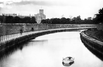
The sea, the lifeblood of the town
In the 13th century the Anglo-Normans settled here and built their castle and town and called it Baile na Srutháin because of its many streams. They later changed the name to Galway after the river on which it stood, and from then on water was a major asset to the town’s development. These streams were to supply many fish, turn many mill wheels, and give access and egress in ages before roads were built, canals dug, or railways laid.

